Post by iconPost by LinusVanpelt | 2020-05-17 | 16:13:16

This race is with the Figaro 3 but with polars from Figaro 2 !?
What are the polars in zezo ?
Good wind all

commenticon 47 Comments
Post by iconPost by toxcct | 2020-05-17 | 19:30:46
It's just a label thing.
You can grab the mono\figaro_2 file, and I'm pretty sure it's what zezo uses too.
Post by iconPost by LinusVanpelt | 2020-05-17 | 20:07:58
Thanks I'll look for the datas on your site re-thanks:)
Post by iconPost by Sea The Stars | 2020-05-18 | 16:48:06
I am sorry but I have no blue lines and no black dots ?! Have you the same problems ?
Post by iconPost by Sea The Stars | 2020-05-18 | 16:52:08
I fin a solution. The poisiton of the boat was wrong !
Post by iconPost by Hamachi SA | 2020-05-18 | 18:21:13
Are we allowed to cut inside the western rocks of Bryher or must we round all of the little islands? I looked in many places but could not find the answer. If you know the answer, where can it be found?

Thx, Hamachi

Post by iconPost by YourMomSA | 2020-05-18 | 18:34:13
If you have the dashboard installed, its map shows the gate you must validate. The short answer is that as long as you go around the buoy, you can do whatever you want with the other islands.

Which should make things very tricky and interesting. I'm not sure if cutting through there is better or not.

If you look at the Scilly's on Google Earth, there are a lot more passages through there in real life than in the game.
Post by iconPost by Luis75 | 2020-05-19 | 15:07:28
What's the meaning of the red and blue dots you can see on Zezo router close to Bryher island?

Post by iconPost by YourMomSA | 2020-05-19 | 15:27:15
This topic explains the dots:

http://zezo.org/forum.pl?tid=7796

Why are some there? Because people are checking routings from there.
Post by iconPost by Luis75 | 2020-05-19 | 15:28:09
Thank a lot YM!
Post by iconPost by YourMomSA | 2020-05-20 | 01:36:42
Armel is going to be unhappy in the morning...
Post by iconPost by BooBill | 2020-05-20 | 02:39:27
Oops
Post by iconPost by zezo | 2020-05-20 | 07:50:59
The Pro sailors were doomed before the start. Looked at the area in Navionics - there is no passage between most islands. Buoy should have been at Bishop rock or somewhere there.


Post by iconPost by Luis75 | 2020-05-20 | 08:20:56
I still have to build experience on VR, but I realize that races around natural buoys are not for me!!!
At the Transat I lost at least 50 positions 1 mile before arrival, here at Tresco yesterday night I went aground 3 times. To this extent, I understand that on VR the buoy and the islands are points on the map. Am I correct to fix waypoints and check the coordinates on Google Maps, verifying that they are safe from the ground?
Post by iconPost by Hardtack | 2020-05-20 | 08:39:28
Yes use waypoints. Use plenty of them.

Do NOT rely on Google Maps. VR uses a different map. The position of land features relative to the buoys will be different in Google Maps. If your course looks safe on Google Maps, it may cross land in VR, and a course that appears to cross land in Google Maps may actually be safe.

Btw, the Dashboard uses Google Maps. You can't rely on it either. What you can rely on is the position of your waypoints course relative to the position of the marks/buoys.

Post by iconPost by Luis75 | 2020-05-20 | 08:57:58
Thanks! But the point is: can I rely on what I see on the map? How close to land can I set a WP and how can I verify that the WP position is safe? Because I have the coordinates of the WP but I do not have a reference where to verify them.
Post by iconPost by zezo | 2020-05-20 | 10:40:05
You should be safe as long as you keep off the VR beaches/rocks. Give it a margin of pixel or two if possible. Better to lose 2 minutes than get aground and lose 20. Also when you are grounded all waypoints disappear, so you can't just bounce around.
Post by iconPost by Hardtack | 2020-05-20 | 13:06:22
Cvetan basically said it all, but just to affirm: what you see in the game UI *is* the map. We don't have any information beyond that.

The VR game server really should perform a land check when validating waypoints.
It would save us a lot of trouble and it wouldn't be hard to implement, but VR have a record of seeing little value in the things that players find useful.

Post by iconPost by Luis75 | 2020-05-20 | 15:01:30
This is what happened during Transat...I put a WP that on the VR map was on the sea and went aground...probably it was too close to land
In any case thank you for your explanations!
Post by iconPost by Velaska | 2020-05-20 | 08:51:10
yesterday night I made a huge error moving badly a waypoint within 10 minutes radius. I had to delete everything and to steer manually trough the rocks. A disaster, I grounded three times loosing hundreds of positions. :((
What I learned is that free steering has zero precision, it was a mess :(((((
Apart from that I have to say that light winds are really cool, this is where beginners like me can learn something..... maybe ! :))

Post by iconPost by zezo | 2020-05-20 | 10:42:49
I'd say it's a beginner's error, but I did the same last night. Had a dinner and finished it about 3 minutes too late to place the waypoints in the channel. Luckily got it mostly right with manual steering (that's my track in the screenshot above. Probably lost 2-3 minutes on the sharp corners.
Post by iconPost by zezo | 2020-05-20 | 10:48:18
The area IRL

Definitely no passage where the game boats passed:


Post by iconPost by zezo | 2020-05-20 | 10:52:30
Green area between Samson and Tresco is 0-2 depth. With rocks.

Post by iconPost by YourMomSA | 2020-05-20 | 13:25:43
Tides in there are something like 14 feet, so it should be fine at high tide. If low tide, you need to be foiling.
Post by iconPost by zezo | 2020-05-20 | 15:07:06
Thanks. I'm not used to tidal navigation, did not even think of that. And there are few navigation aids there, and a ferry route.
Post by iconPost by DancingBrave | 2020-05-20 | 23:15:25
"I'm not used to tidal navigation"
Me neither in my part of the world (Sardinia, Italy).

Ironically our next turning point, the Channel Islands (Guernsey,Jersey etc),probably have the most dramatic/horrific tidal range and currents of anywhere I've sailed! Would be great if somehow VR could incorporate a current aspect into the game - would make light air races more interesting :)
Post by iconPost by YourMomSA | 2020-05-21 | 00:22:31
They'd need to add "anchor" as a sail option.
Post by iconPost by Luis75 | 2020-05-21 | 18:18:31
...and sea depth and credits to pay more rope/chain, thus reducing performance because of weight :):)
Post by iconPost by zezo | 2020-05-20 | 15:11:12
One more thing about waypoints and ground - visual land outline depends on the UI quality setting. HQ seems accurate, but the LowQ has smaller land outline. Got me grounded in the last RORC 600 (Laptop uses built-in Intel GPU and HQ is extremely slow)

There is also some kind of parallax, so the track/coast relation changes slightly as you pan the map around.
Post by iconPost by YourMomSA | 2020-05-20 | 18:54:17
Is it just me, or did they remove Armel?

It's a shame... He's a great sailor and they promoted the event as a chance to race against him. I don't think anyone expected him to be highly competitive in the virtual format, and waking up to discover your boat ran aground during the night is not unusual in the game. I thought he would have resumed racing when he woke up this morning, but I guess not. Bummer.

Some of the other pros have done reasonably well in some of the other virtual races. Particularly the first 3-4 pros in AG2R. I think some of them learned a lot about the game during Great Escape and decided to be serious enough about AG2R to do well.
Post by iconPost by YourMomSA | 2020-05-20 | 20:28:37
Anybody know if we can sail through St. Catherine's Breakwater a Jersey? It looks like yes...
Post by iconPost by GeGaX | 2020-05-21 | 18:54:10
Yep, you can ;)
Post by iconPost by BooBill | 2020-05-21 | 00:44:43
Show us the way Mom!
Post by iconPost by YourMomSA | 2020-05-21 | 00:54:16
I'll probably be asleep...
Post by iconPost by YourMomSA | 2020-05-21 | 20:46:10
I'm seeing a bigger finishing circle on my phone than on my computer... ?? Anyone else?
Post by iconPost by zezo | 2020-05-21 | 20:58:15
It was set at 3 nm initially, but the staring point was within the circle and the projected track did not work.

It took them about 5 days to notice and fix it few hours before the start.

The races should not be cached client-side, but who knows. Still 2 nm here on a PC.
Post by iconPost by Hardtack | 2020-05-21 | 20:59:30
They look identical to me (Chrome/Linux vs. Andriod App). Maybe a zoom problem?
Post by iconPost by YourMomSA | 2020-05-21 | 21:00:50
IOS is still showing it outside the starting point. I wonder what'll happen if I access the race o the phone after crossing the phone's circle and before crossing the computer's.

Answer: The phone said "arrival pending for approval" but the boat continued sailing and the arrival wasn't actually processed until I crossed the smaller circle. So the end result is fair. Just temporarily confusing.
Post by iconPost by shockwave11 | 2020-05-21 | 23:16:02
No it’s a disaster. So many boats myself included crossed the circle and got a pending arrival notice like normal and went off to make breakfast. To then get an email 15 mins later to say I was aground. I ended up having to turn around and actually ploughed the finish asterix down the harbour to finally finish. I lost 200 places and some mates are still on the beach an hour later. The race needs to be abandoned.
Post by iconPost by YourMomSA | 2020-05-22 | 00:17:39
Ah... yeah... If I had been looking at IOS only and hadn't been fortunate enough to avoid running aground, I'd be pretty unhappy about that too. My point about fairness was just to say that the difference wasn't enabling IOS users to finish sooner than non-IOS users.
Post by iconPost by Shelisteam | 2020-05-22 | 11:27:29
I had the same problem. I have crossed the circle line , got pending arrival notice and gone to sleep. When I woked up - I was aground and lost 5000 places.
Second think: I was sailing close to the shore and the indicator of the heading was safe (no messege about danger of aground) , I was watching my laptop and shit "you are aground" - this bugs steals fun from the game.
Post by iconPost by Acg1 | 2020-05-22 | 02:36:07
Oh for God’s sake .... all those sneaking across the finish line in attempt to grab a few extra places who are using app version therefore didn’t actually finish until they sailed further . But when the shortest route is to the north eastern shore area they just grounded and never “finished”.... are we saying that they KNEW of the issue but failed to correct it or in some manner communicate it .... wow ... guess anyone who spent dollars on that race are now going to question how often that might happen elsewhere - I certainly would.
Post by iconPost by Acg1 | 2020-05-22 | 02:40:32
YourMom .... nope, don’t agree sorry .... certainly didn’t produce a fair outcome. I know that’s a whinge but when produced by a known issue it has a completely different complexion. If wondering ... see track of Lionheart and ACG1. Bit of friendly last minute action but I was watching it as we crossed and it come down to the wire. Jokes about scraping the shoreline to squeeze through, gel coat removal to make it work etc etc - I get the “finished pending” - left to get other things done - come back to find .. nope not finished. All fun and games and a truly “first world problem” - but hang on, this is a commercial product isn’t it?
Post by iconPost by YourMomSA | 2020-05-22 | 04:31:04
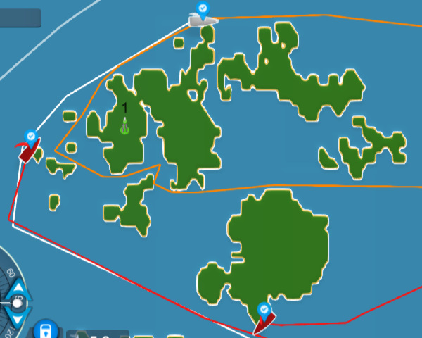
Again, as I said in response to shockwave, I hadn't recognized yet that the scenario being described might happen. My concern was about the possibility that IOS users might actually get a finish at the 3 nm circle, only to have non-IOS users have to sail an extra mile before they could record a finish. When I said it was fair, my point was simply that the scenario I had in mind didn't happen. IOS users still had to sail the last mile, so the finishes were recorded at the same line.

But... it hadn't occurred to me yet that IOS users who thought they had finished and actually hadn't would suffer those kinds of impacts. When shockwave mentioned it, I corrected my statement. For anyone sailing exclusively on IOS who couldn't see the 2 nm circle and race to that one, the result was indeed unfair.

Regarding this happening elsewhere... I've never seen this particular issue, but if you race enough, you'll see occasional debacles. I've seen islands with misrepresented shorelines, where dozens of boats "ran aground" off of the visible island, and mandatory invisible gates that didn't get validated, and untimely server crashes, etc... Most of those are from the past and their systems are far more stable now... but human mistakes still happen and someone screwed up here. These screwups aren't common anymore, but they happen.
Post by iconPost by Acg1 | 2020-05-22 | 06:38:27
Pretty easy to fix this one ... just take server time at the 3NM radius (assuming that was iOS phantom finish line distance) as finish time for all boats ...
Post by iconPost by zezo | 2020-05-22 | 07:56:04
Not going to happen. They don't have all the data, one can argue that with 3 mile circle he'd have different strategy.

And it never happened in 10 years.
Post by iconPost by Acg1 | 2020-05-22 | 21:48:20
How can they not have the data? I can still log in to that race and see my race trail...same would apply to all other boats ... why would they not have access to all that data? In terms of a different race strategy if knew 3NM ... not so much as those who thought it was 3NM but it wasn’t... at least everyone “raced” through the 3NM position... don’t understand logic here nor how the data would not still be available. Data would have to be available at least until race closed - still some racing isn’t there?
Post by iconPost by LinusVanpelt | 2020-05-22 | 10:48:21
2 milles = 3 kilometers
Would there not be a concern for unity and conversion in a programm ???
border
Topics list
Posts
border
5
border
border
Copyright 2009 by ZEZO.ORG. All Rights Reserved.